| Mobile,
Ala.--University
of South Alabama hurricane expert Dr. Keith Blackwell used
the latest in microwave satellite technology to look inside
Hurricane Katrina’s storm clouds, leading to the discovery
of a second, or outer, very potent eyewall, which extended
severe hurricane winds far outward from the storm’s
center.
His findings explain for the first time why the Category
3 hurricane delivered catastrophic damage over such a wide
area of land, creating the biggest natural disaster in America’s
history.
Conventional satellite imagery hid the dangerous outer eyewall
that lurked beneath the dense clouds swirling counter-clockwise
around the hurricane’s eye as it roared toward the Mississippi-Louisiana
line in the early morning hours of Aug. 29, 2005.
According to Blackwell, discovery of the outer eyewall explains
the extremely heavy damage to the coastline, extending unusually
far to the east through Jackson County, Miss., miles eastward
from Katrina’s eye. The outer eyewall came ashore on
the Mississippi coast shortly after daylight while the hurricane’s
eye was still well offshore. High winds pounded the coast
for hours before the eye finally made landfall. Blackwell
said instruments dropped into the outer eyewall from aircraft
recorded winds between 140 to 145 miles per hour inside the
eyewall at an altitude of 1,500 feet. He estimated sustained
winds near the ground of approximately 105 miles per hour
with much higher gusts in the torrential rain. This outer
eyewall swept across the entire Mississippi coast as far east
as Pascagoula. It was then followed by the more intense inner
eyewall, accompanied by a record-breaking 28-foot storm surge,
over the western Mississippi coast later that morning.
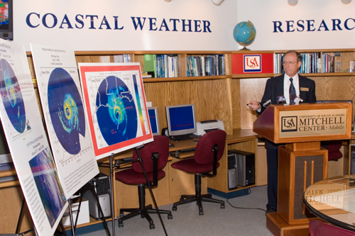
Blackwell, an associate professor in the USA department of
earth sciences and a hurricane forecaster and tropical weather
research center specialist with USA’s Coastal Weather
Research Center, said hurricane researchers have known about
outer eyewalls for a long time. Previous research has shown
that a double eyewalls often form in intense hurricanes, but
only persist for a day or two, thus many strong storms that
previously exhibited two eyewalls over the open ocean may
not retain both until landfall. However, the development of
microwave satellite imagery is helping researchers to learn
more about the evolving internal structure of hurricanes and
their potential to grow quickly in size as the original eyewall
becomes surrounded by a much more expansive outer eyewall.
“If residents of eastern Jackson County near Pascagoula
had known about this outer eyewall, or even the possibility
that such a thing could occur in the hours before Katrina’s
eye made landfall, then their focus may have shifted from
the New Orleans and western Mississippi coastline areas to
their own safety. In addition, many people more directly in
the path of the hurricane were suddenly surprised by the early
arrival of strong damaging winds on the coast well in advance
of Katrina’s center or extremely high tides,”
said Blackwell.
Blackwell said as the second eyewall approached the Mississippi
coastline, the strong easterly winds were actually pushing
water to the west, parallel to the coastline, rather than
to the north onto land as the hurricane would do later once
the eye made landfall. “Initially, high winds in the
outer eyewall struck the Mississippi coast up to three to
four hours before the highest water arrived. The problem with
water created by the storm’s devastating tidal surge
arrived later,” explained Blackwell.
For thousands of Alabama and Mississippi residents still
fighting insurance companies over whether wind or water damaged
or destroyed their structures, Blackwell’s findings
could mean a difference in how some cases are settled.
Other storms with double eyewalls have delivered devastating
wallops to coastal areas, including the outer eyewall of Hurricane
Ivan on Sept. 12, 2004, as the storm’s eye and inner
eyewall passed to the south of Grand Cayman. The outer eyewall
packed sustained winds of 150 miles per hour with gusts to
171 miles per hour, destroying 95 percent of the island’s
buildings and leaving damages of $1.85 billion. The building
codes on Grand Cayman at that time were similar to the strict
codes enacted in south Florida following Hurricane Andrew.
Blackwell said developing data on second eyewalls can help
public safety officials determine wider evacuation areas and
give first responders life-saving information as they respond
to storm emergencies. It can also help residents reach a better
decision on evacuation plans.
“Traditionally, people have looked at hurricane warning
areas and thought they were relatively safe if their residence
was not in the direct path of the eye or not near the center
of the warning zone. What we are learning about outer eyewalls
can change how they perceive the threat a hurricane may pose
to areas closer to the edge of that zone,” said Blackwell.
The USA Coastal Weather Research Center, a self-supporting
operation of the department of earth sciences, began operation
on Jan. 1, 1988. Located in the Mitchell Center on the main
USA campus, the weather center consists of a meteorological
laboratory, information center and archive.
Hurricane Katrina Image
at 6:45 a.m. CDT August 29, 2005
Background
Paper: Hurricane Katrina and Double Eyewalls by Keith Blackwell
Fact Sheet: Double
Eyewalls and Hurricane Katrina |