Archaeology in Action: The Virginia Street Site (Part III)
Posted on February 2, 2023 by Rachel Hines
The Virginia Street Site is located south of downtown Mobile on Virginia and South Franklin streets and has a history spanning 2,000 years. The first post in this series covers the early history and archaeology at this site, while the second post covers the past 200 years on the block. Now we’ll dive deeper into the history of the Owens Family, who owned the property at 906 South Franklin Street for over six decades and through three generations.
Because the Virginia Street Site is in an urban area, we’re able to learn a lot about the site’s 20th century residents through historic research, like US Census Records (below) and Mobile City Directories. These documents help us interpret the archaeological material recorded at the site. Through our research, we’ve learned about the family of Jesse and Lillie Owens. (Jesse happens to share a name with the famed Olympic athlete, also from Alabama). They came to Mobile from Georgia around 1894 and purchased the lot on South Franklin Street from George and Mary Holman in 1897. Jesse and Lillie had two children: a daughter, Queenie Owens Waters, born in 1892, and a son, Nathan Kelley Owens, born in 1894.
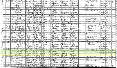 1900 US Census records with the Owens Family highlighted in green and yellow. Census
courtesy of the National Archives and Records Administration.
1900 US Census records with the Owens Family highlighted in green and yellow. Census
courtesy of the National Archives and Records Administration.
During this time, the Owens Family was one of few families who owned a home Down the Bay. Between 1900 and 1950, about 80% of the residents in the neighborhood rented their homes, making home ownership an invaluable asset. The 1915 Sanborn Fire Insurance Map shows a shop attached to the house (below), and the 1907 Mobile City Directory lists Jesse as a grocer. Small, community grocery stores were common at this time; in the 1950s, there were 50 grocery stores in the Owens Family’s neighborhood. In addition to running the store, Jesse worked for the L & N Railroad for over three decades, and Lillie worked as a dressmaker.
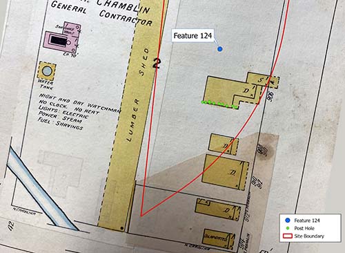 The 1915 Sanborn Fire Insurance Map with features from the 2022 archaeological excavations.
The row of post holes is in green, while Feature 124, a large trash pit, is in blue.
The “D” on the structure stands for “dwelling,” while “S” stands for “store.” 1915
Sanborn Map courtesy of the Mobile Municipal Archives.
The 1915 Sanborn Fire Insurance Map with features from the 2022 archaeological excavations.
The row of post holes is in green, while Feature 124, a large trash pit, is in blue.
The “D” on the structure stands for “dwelling,” while “S” stands for “store.” 1915
Sanborn Map courtesy of the Mobile Municipal Archives.
Jesse and Lillie eventually purchased the lots at 912 and 914 South Franklin Street as well. 914 was sometimes rented to tenants, providing another source of income. Their son, Nathan Kelley Owens, moved in at 912 with his wife Estelle. They had four sons: Nathan Jr., Jessie, Charles, and Clovice. Jesse and Lillie’s daughter, Queenie Owens Waters, was a teacher at the Josephine Allen Institute, an African American school founded in the late 19th century.
This past year, archaeological excavations were conducted at the Virginia Street Site around the former Owens home. A trench in the southern part of the site revealed a series of post holes (above in green). Post holes were dug into the earth so a post could be inserted into it. This was done to place pilings for a structure or to build posts for a fence line, for example. When the post decays, it leaves a darker spot in the soil where the post was located. Archaeologists use these features to understand where past structures were located on the landscape.
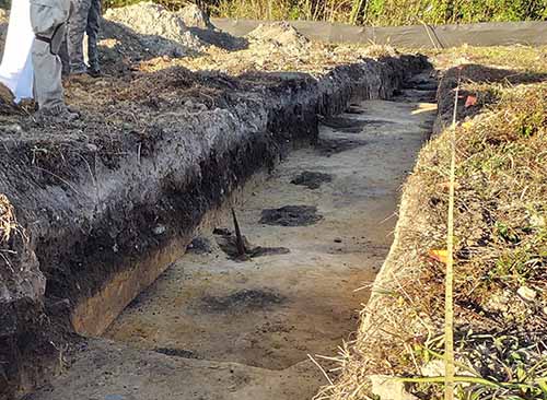 Trench excavation with a line of post holes (the round, dark soil spots).
The post holes were aligned roughly east-west in a 34-foot line (above). According to historic documents, this was the length of the structure at 906 S. Franklin Street. Locating these postholes allowed us to determine the probable location of the Owens house. There were several features located in the vicinity of the house that were likely created by the Owens Family.
One of the major features excavated near the property was Feature 124, a trash pit containing over 3,000 artifacts (below). The sheer volume of artifacts speaks to the family’s long-term habitation of the property. Feature 124 contained a number of children’s items, such as slate pencils, marbles, and fragments of porcelain dolls and tea sets, which were likely used by the Owens children and other kids in the neighborhood.
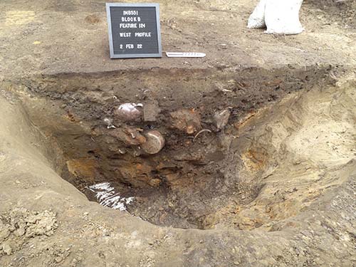 Feature 124 in profile halfway through the excavation of the trash pit. Note the dense
trash deposit and the whole vessels visible in the soil.
Feature 124 in profile halfway through the excavation of the trash pit. Note the dense
trash deposit and the whole vessels visible in the soil.
There was also a large quantity of glass bottles and stoneware jugs, many of which are whole. The jugs and bottles may have been related to the store on the property, or they may have been discarded by the family when they when they moved. They may also be discarded from a hit house, or a place where alcohol was illegally sold. In interviews for the Down the Bay Oral History Project, community members recall these informal package stores as gathering places, as well as opportunities for families to supplement their income.
The trash pit also contained a large amount of animal bone, including cow, chicken, pig, and deer. Based on this feature, the family primarily ate domestic animals, like cow, chicken, and pig, as well as shellfish. The occasional wild game was used to supplement this diet. The artifacts and faunal remains found in the trash pit paint a picture of a self-sufficient and resourceful family.
The Owens Family was forced to move from their home in the 1960s, when the properties in the area were acquired to construct Interstate 10. Clovice Owens, the youngest grandson of Jesse and Lillie Owens, lived in the house at 906 South Franklin Street until 1962. I-10 construction, and subsequent city urban renewal efforts, transformed the neighborhood and displaced many long-time residents, like the Owens Family.
The excavations at the Virginia Street Site are part of the I-10 Mobile River Bridge Archaeological Project, an effort to excavate and record 15 archaeological sites before the I-10 Mobile River Bridge and Bayway Project. We will continue to share results from our research on this blog and on social media, so please follow along!
References:
Carr, Philip J., Emily J. Warner, M. Anne Dorland, Bonnie L. Gums, Nicolle Lang, Brittney N. Ingram, Will B. Marriott, Jordan G. Temples, James D. Norris, and Kern Jackson (2019) Phase II Archaeological Testing of Site 1MB498. University of South Alabama Center for Archaeological Studies. On file at USA Center for Archaeological Studies.
Christopher, Raven and Sarah Price (2022) Field and Lab Management Summary: 1MB551. University of South Alabama Center for Archaeological Studies and Wiregrass Archaeological Consulting. On file at USA Center for Archaeological Studies.
Gums, Bonnie (2019) Phase II Archaeological Testing at Site 1MB551. University of South Alabama Center for Archaeological Studies. On file at USA Center for Archaeological Studies.