Archaeology in Action: The Virginia Street Site (Part II)
Posted on December 14, 2022 by Rachel Hines
The Virginia Street Site is located south of downtown Mobile on Virginia and South Franklin streets and has a history spanning 2,000 years. While the first post in this series examines the early history and archaeology at this site, this one covers the past 200 years on the block.
Historic ownership documentation of this property begins with Spanish land grants in 1792. However, being located so far south of the city center, this area is generally left off maps until the mid-1800s. At that time, the block was subdivided into three lots and it became a residential neighborhood. These turn of the century residences form the main archaeological component found at the Virginia Street Site and include three lots: 401 Virginia Street and 906 and 908 South Franklin Street.
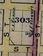 Excerpt from the 1878 Hopkins Atlas of Mobile. Courtesy of the Mobile Public Library, Local History and Genealogy.
The first house on the block appears in the 1878 Hopkins Atlas of Mobile (above). It isn’t clear who built this house, but George Washington purchased it in 1883. He is listed as a mulatto steamboat hand who was born in Alabama in the 1880 census. At the time, he lived with his wife Catherine, son Westley, and daughter Joanna. A few shallow pits containing mid-19th century refuse, including ceramics and glass, were found in the center of the site and were likely related to the Washington household. Additionally, archaeologists identified several postholes dating to this time period. These may be related to the house or to a fence demarcating the property boundary.
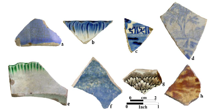
Ceramics found during Phase II archaeological testing. The ceramics in the top row were common during the 18th-19th century, while those in the bottom row were common during the 19th-20th century. (a) French faience (b) blue edge-decorated pearlware (c) blue Willowware transfer print pattern (d) blue transfer-printed whiteware (e) green edge decorated whiteware (f) blue sponge-decorated whiteware (g) brown transfer-printed whiteware (h) Rockingham-glazed yellowware.
This parcel eventually became 908 South Franklin Street and was rented to tenants throughout the 1900s. A cinderblock patio, likely associated with this property, is visible in a 3D model of the archaeological excavation at the Virginia Street Site. 906 South Franklin Street was just north of 908 (below). This lot was sold to Sarah Parsons for $28 in 1881. She was a Black woman born in Mississippi in 1815. In the 1880 census, she is listed as a domestic servant and lived at 116 Savannah Street with her grandson, George Holman, and his wife. They don’t appear to have lived at 906 South Franklin Street. When Sarah died in 1897, George sold it to Jesse and Lillie Owens for $180. The price increase indicates the Parsons may have built the house while they owned the property.
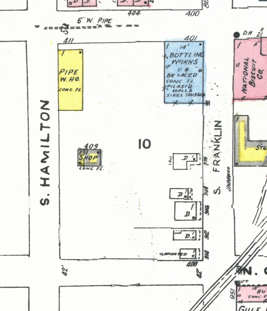
1955 Sanborn Fire Insurance Map showing the properties at the Virginia Street Site: 401 Virginia Street and 906 and 908 South Franklin Street. Courtesy of the Library of Congress.
401 Virginia Street was north of 906 South Franklin Street. Catherine McRae Hampstead owned the land from 1869-1907, but there’s no indication she used or occupied the property during that time. The McRaes were influential in the Confederate South; Catherine’s brother Colin J. McRae was a businessman in Alabama, and her brother John J. McRae served as a Governor and Representative of Mississippi. The family lived in an exiled Confederate colony in British Honduras after the Civil War. They owned a several in Mobile which they slowly sold off from afar.
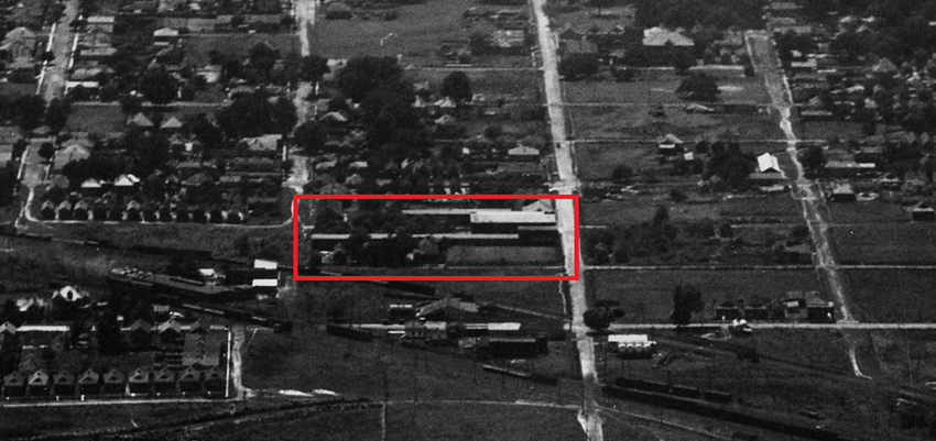
1922 aerial image of Mobile taken by the Air Force. The Virginia Street Site is outlined in red, with 401 Franklin Street on the right. Courtesy of the National Archives.
401 Virginia Street remained vacant throughout the early 1900s. It appears empty in this 1920s oblique aerial photo (above) and historic maps do not depict any structures there. It may have been used for agriculture. During archaeological investigations, our team noted plow scars were noted in the subsoil throughout the entire site, suggesting it was farmed prior to development. They also uncovered a cow burial on the south end of the lot. Community members also took advantage of the space, as it appears it served as a local pet cemetery. Archaeologists excavated three dog burials, which were aligned north-south line at regular intervals. The placement suggests the burials followed a fence or property line.
In 1943, Eugene Loeffler bought the property and opened a Grapette Bottling Plant (below). Grapette produced a popular fruit soda and owned the property through the construction of I-10 in the 1960s. Grapette was subsumed by Pepsi in 1975, which is likely when they took over the plant. Most of the archaeological features in the northern half of the site are associated with the bottling works. We excavated a large pit filled with bottles and fragments, unidentified metal, and thousands of flattened bottle caps. These bottle caps may have served as parking lot pavement based on the high density in that area.
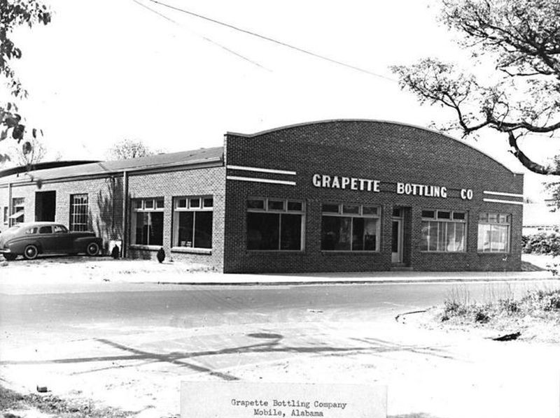
Grapette Bottling Plant at 401 Virginia Street in the 1940s. Photo courtesy of Jerry Reeves, The Doy Leale McCall Rare Book and Manuscript Library, University of South Alabama.
The excavations at the Virginia Street Site are part of the I-10 Mobile River Bridge Archaeological Project, an effort to excavate and record 15 archaeological sites before the I-10 Mobile River Bridge and Bayway Project. We will continue to share results from our research on this blog and on social media, so please follow along!
References and further reading:
Christopher, Raven and Sarah Price (2022) Field and Lab Management Summary: 1MB551. University of South Alabama Center for Archaeological Studies and Wiregrass Archaeological Consulting. On file at USA Center for Archaeological Studies.
Gums, Bonnie (2019) Phase II Archaeological Testing at Site 1MB551. University of South Alabama Center for Archaeological Studies. On file at USA Center for Archaeological Studies.
Letters from Catherine McRae from the Alabama Department of Archives and History
Colin McRae Collection at the South Carolina Confederate Relic Room and Military Museum
Learn more about our investigation of the Virginia Street Site:
Part I: Early history at the Virginia Street Site
Part III: The Owens Family of 906 South Franklin Street