Archaeology in Action: The Union Hall Site
Posted on October 10, 2023 by Rachel Hines
The Union Hall Site, also known as 1MB513, and the adjacent Bender Site, or 1MB555, are the first two sites we started excavating for the I-10 Mobile River Bridge Archaeology Project back in November 2021. These two sites occupy the same city block bound by the Hank Aaron Loop and Madison, South Royal, and Canal Streets. The Union Hall Site, named for the Union Hall building that once sat on this lot, comprises the northern part of the block, while the Bender Site, named for the Bender shipyard, covers the south section. Our archaeological investigations largely focused on the northern part of the block, because the southern part of the site lacked intact cultural deposits.
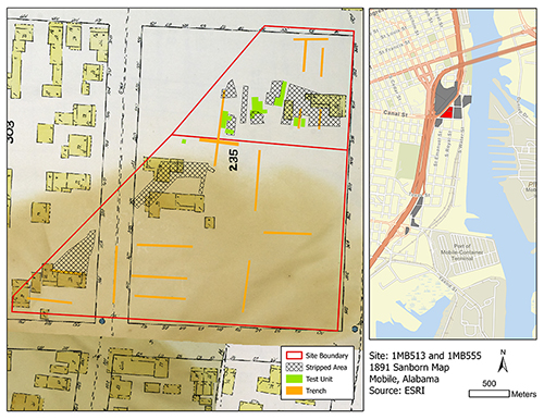
1904 Sanborn Fire Insurance Map showing our excavations at the Union Hall and Bender Sites in 2021-2022. Map courtesy of the Library of Congress.
In the northern part of the block, we documented numerous features ranging from the colonial period into the late 20th century. You can explore our excavations through a 3d model of the site created by Dr. Alex Beebe of the University of South Alabama Department of Earth Sciences. One interesting feature was a large, infilled drainage made or modified by humans, based on shovel and hoe marks. It may have been a ditch to drain the marshy waterfront or a colonial drainage feature shown on a 1763 map of Mobile (below).
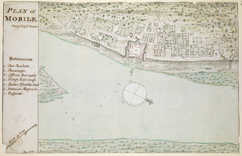
1763 Map of Mobile created by Philip Pittman. The ditch can be seen in the upper left corner of the map on the outskirts of town. Map available digitally here. Courtesy of the Simon B. Leventhal Map and Education Center at the Boston Public Library.
This site had our highest concentration of colonial-era features on the project. In addition to the ditch, we also documented several barrel wells and other large deep pits dating to the colonial era. Research on these features were presented at the 2022 Southeastern Archaeological Conference. Archaeologist Sarah Mattics shared her research on three barrel wells, including the one shown below. Barrel wells are well shafts lined with wooden barrels and are found in colonial contexts; however, there are uncommon in Mobile due to the proximity to Mobile Bay and propensity for flooding.
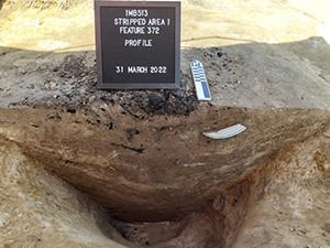
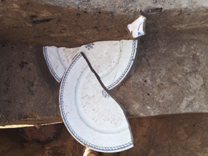
Left: Colonial-era barrel well excavated at the Union Hall site. Right: Two halves of a French faience plate (which can be seen in the wall in the left photo). Learn more about the faience plate in this short video.
Kelsey Clark, Emily Warner, and Lindsey Howell Franklin presented their research into “Large Deep Pits,” an ubiquitous (but ambiguous) colonial feature (shown below). Both of these features had a high density of artifacts and will give us insight into daily life at the time. These features are important, because we have little documentary evidence for land ownership and use at this time.
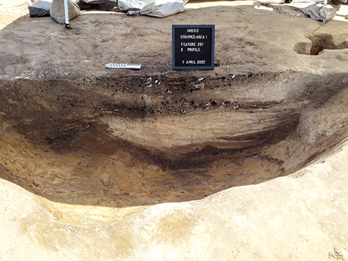
The “Large deep pit” at the Union Hall Site shown in profile view. Several distinct soil layers are visible, including a thick deposit of sand, which may have been deposited by a storm. Learn more about soil layers, or stratigraphy.
The 1840 Troost Map is the earliest map with detailed ownership information. It shows that, at that time, these sites were almost entirely owned by Samuel Allen. Allen was a merchant who operated a cotton pickery at this site. Throughout the 19th century, more houses were built on the block and it slowly became a residential neighborhood. By the mid-20th century, it had become mostly industrial. As we continue our analyses, we look forward to learning more about the different phases of land use at this site. The Union Hall and Bender Sites are two of the 15 sites we excavated for the I-10 Mobile River Bridge Archaeology Project. Stay tuned to learn more about our work at other sites!