Archaeology in Action: The Madison Street Site
Posted on August 16, 2023 by Rachel Hines
We excavated the Madison Street Site, or 1MB532 for the I-10 Mobile River Bridge Archaeology Project in 2021-2022. This site is across the street from the Eslava Street Site and is bound by Royal Street, Madison Street, South Water Street, and the Hank Aaron Loop. The Madison Street Site resembles the Eslava Street Site in many ways: It was once a low-lying swampy area along Mobile Bay and the land was created in the early 1800s. It was also primarily industrial, housing lumber mills, warehouses, and factories in the 19th and 20th centuries.
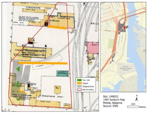 1904 Sanborn Fire Insurance Map of the Madison Street Site with our 2021-2022 excavations.
Map
1904 Sanborn Fire Insurance Map of the Madison Street Site with our 2021-2022 excavations.
Map
courtesy of the Library of Congress.
Our team identified evidence of landfilling; layers of fill at the Madison Street Site included ballast stones, lumberyard refuse, brick rubble, possible dredge spoil, and other soil deposits (below). Dr. Alex Beebe of the University of South Alabama Department of Earth Sciences created a 3d model of one of the trenches at the site which shows these layers of fill.
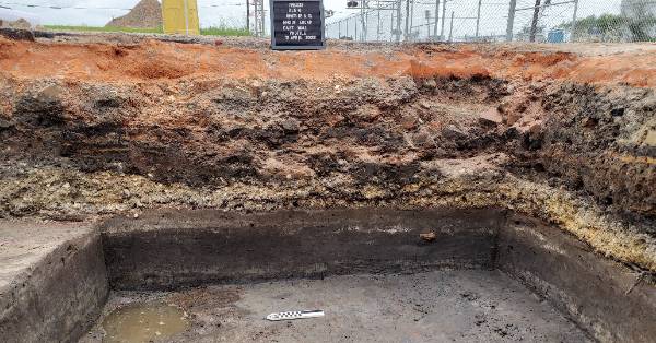 Layers of soil at the Madison Street Site with evidence of landfilling through time.
In 2019, while testing for the I-10 project, archaeologists encountered the former swamp beneath 1.5 meters of fill. It was a black sand layer with remains of tree stumps. Because of this, our excavations in 2021-2022 focused on the west half of the site, where there was high ground prior to the 19th century. We found the remains of several brick industrial structures at this site (below). Though the land was created after European settlement, we also found some colonial era artifacts. These artifacts were likely deposited by dumping refuse in the river, as well as by hurricanes and other flooding events.
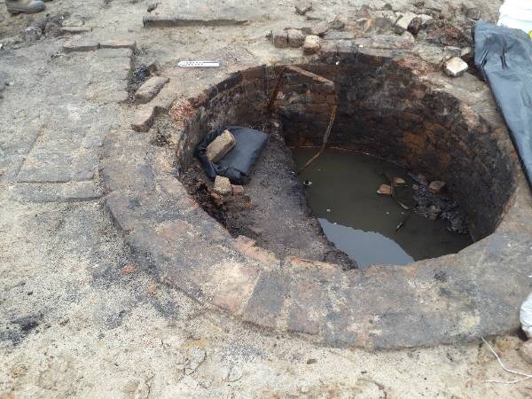 A brick cistern located in the southwestern corner of the site where the Sash and
Door Company was
A brick cistern located in the southwestern corner of the site where the Sash and
Door Company was
located. It may have been related to that or to the earlier lumber mill at the site.
In addition to our excavations, we took environmental samples. ALDOT conducted deep test coring to learn more about the former riverbed, river edge, and marsh, and how the landscape changed through time. Geoarchaeologist Howard Cyr also collected soil samples for Optically Stimulated Luminescence (OSL) dating, which measures the last time sediment was exposed to light or heat. Four of these samples were from possible storm deposits, which could tell us about the history of hurricanes in Mobile before written records were kept.
As we continue our analysis, we’re looking forward to learning more from the data we collected at the Madison Street Site. The Madison Street Site is one of 15 sites that we’ve investigated for the I-10 Mobile River Bridge Archaeology Project. Stay tuned to learn more about what we’ve discovered so far!