Archaeology in Action: Excavating a Brick Tenement
Posted on July 6, 2023 by Chelsea Cook
On the corner of South Royal and Madison Streets, archaeologists uncovered the remains of a large brick structure while working on the I-10 Mobile River Bridge (MRB) Archaeology Project. Originally constructed in the mid-19th century as part of Otis Mills, it was later converted to a residential tenement building. The site, known as the Old Water Street Site (or 1MB552), was one of 15 sites excavated for the I-10 MRB Project.
William Otis’s mill was established in 1859 and occupied several blocks along the Mobile waterfront. According to historic maps, the brick building was part of a pail factory, and was converted to tenement housing by 1880. The building was demolished sometime between 1904 and 1915, and by 1924, the property was used as a sheet metal works.
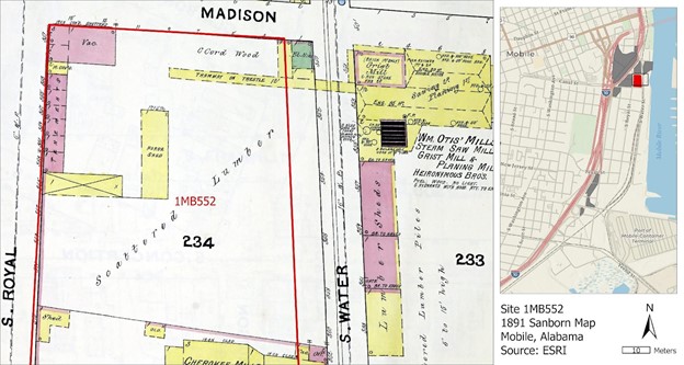
This 1891 Sanborn Fire Insurance Map shows the location of the brick structure in the top left corner. On a Sanborn Map, red indicates a brick structure, while yellow indicates wood. Note that the word “Tenements” appears across the building. The map on the right shows the location of the site (in red) and the other sites for the I-10 MRB Archaeology Project (in gray).
Historical maps show the brick structure had a tin over slate roof and consisted of
9 rooms, 7 of which we excavated. Archaeological excavations revealed information
about how the building was constructed. The structure consisted of articulated brickworks,
including interior walls that separated rooms and the exterior walls of the structure
itself (below).
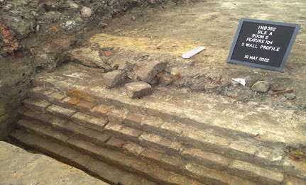
The base of one of the brick walls that separated the rooms of the structure.
In places, we also recovered remains if the original wood floor under demolition debris
(below), as well as structural cross beams that likely fell from the ceiling when
the building was demolished. The building was located on man-made land atop what was
once marshland along Mobile Bay. To prevent settling of the building into the former
marsh, it appears the foundation included a crushed shell lining.
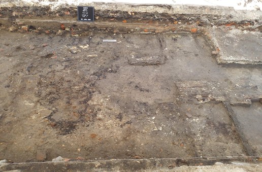
Remains of the wood floor from the tenement structure. Note the brick rubble in the excavation unit wall at the top of the photo.
Archaeological evidence also identified how the structure changed over time. Some
remodeling was done to the exterior walls, possible as a result of hurricane damage. Additionally, around the turn of the 20th century, one of the rooms on the interior
of the structure was removed. This divided the building into two sections, separating
the northern two rooms from the southern part of the structure. The conversion of
the middle room’s interior walls to exterior walls is visible the soil layers (below).
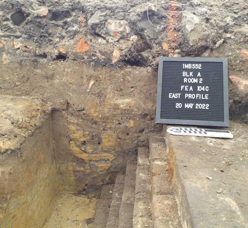
The builder’s trench between two rooms in the structure. The mottled orange and brown soil deposit evidences how the trench was dug into during remodeling.
At that time, the 1904 map shows the northern part of the structure was used as an
office, two of the rooms had been converted to lumber storage, and four of the rooms
were still being rented as tenements. As we continue our artifact analysis, we hope
to learn about the people who lived in the tenement house.
This information was presented by Thomas J. Grace at the Southeastern Archaeological Conference in Little Rock, Arkansas. Check out his poster or take a look at our other posters from the conference.